
Historic maps
The Ordnance Survey maps tell an interesting story about the history of the parish.
The 1865 edition of the one-inch-to-one-mile map of the Cambridge area (the first printed using electrotype setting) shows that southern reaches of the residential development of Cambridge only extended as far as the area of land that is now the University Botanic Garden, and the railway station (opened 20 years previously) is completely outside the residential area. The main thoroughfares of Hills Road, Cherry Hinton Road and Long Road, which partly define the parish boundary, were in existence in 1865, but at this time there was no hint of Mowbray Road, which is the other parish boundary thoroughfare.
1865 map centred on the parish and beyond. Click here for a larger map in pdf format (5.5 MB).
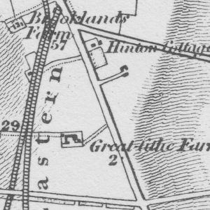
The first 6-inches-to-a-mile map of the area was published in 1889. What is now Homerton College was then still Cavendish College. The site that is now our church was part of Jordan's farm (this can be seen in the 1865 map but without the name being given). Virtually the whole of the modern parish of St John's was farmland. The only parish roads that appear to have been designated – albeit without any buildings – were Cavendish and Hills Avenues. At this time most of the parish lay outside the Cambridge town boundary (note that at this time Cambridge did not have the designation of a city; this was awarded in 1951) and instead was part of the village of Cherry Hinton. The only part of the parish lying within Cambridge was the land around the junction of Hills Road and Cherry Hinton Road.
1889 map of the vicinity of the parish.
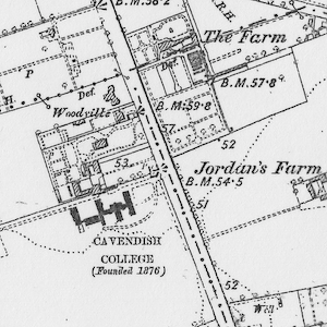
The 1904 map takes us to just after the foundation of the church of St John's, which then was only half the size of the current church building. We can see how quickly the residential area in the western part of the area bounded by Hills Avenue, Hills Road and Cherry Hinton Road has developed since 1889. There is still no sign of Mowbray Road, or any development in the southern part of the parish.
1904 map of the vicinity of the parish.
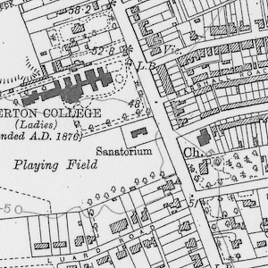
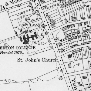
In the 1925/7 revision of the maps, we see the wider development of the parish. This now includes Mowbray Road (although not yet Perne Road, which today is the northern extension of Mowbray Road forming the modern city ring road). There is a larger density of housing, including building along Cherry Hinton Road and Hills Road. By this time the city boundary has been extended to include the residential area of the parish of St John's, which forms the edge of the city. This map still precedes the extension of the church.
1925/7 map of the vicinity of the parish.
If you are interested in looking further at the maps of the area, we can recommend this approved site as a good source (although we obtained our copies of original maps from libraries).